


Nahal Roded
Background
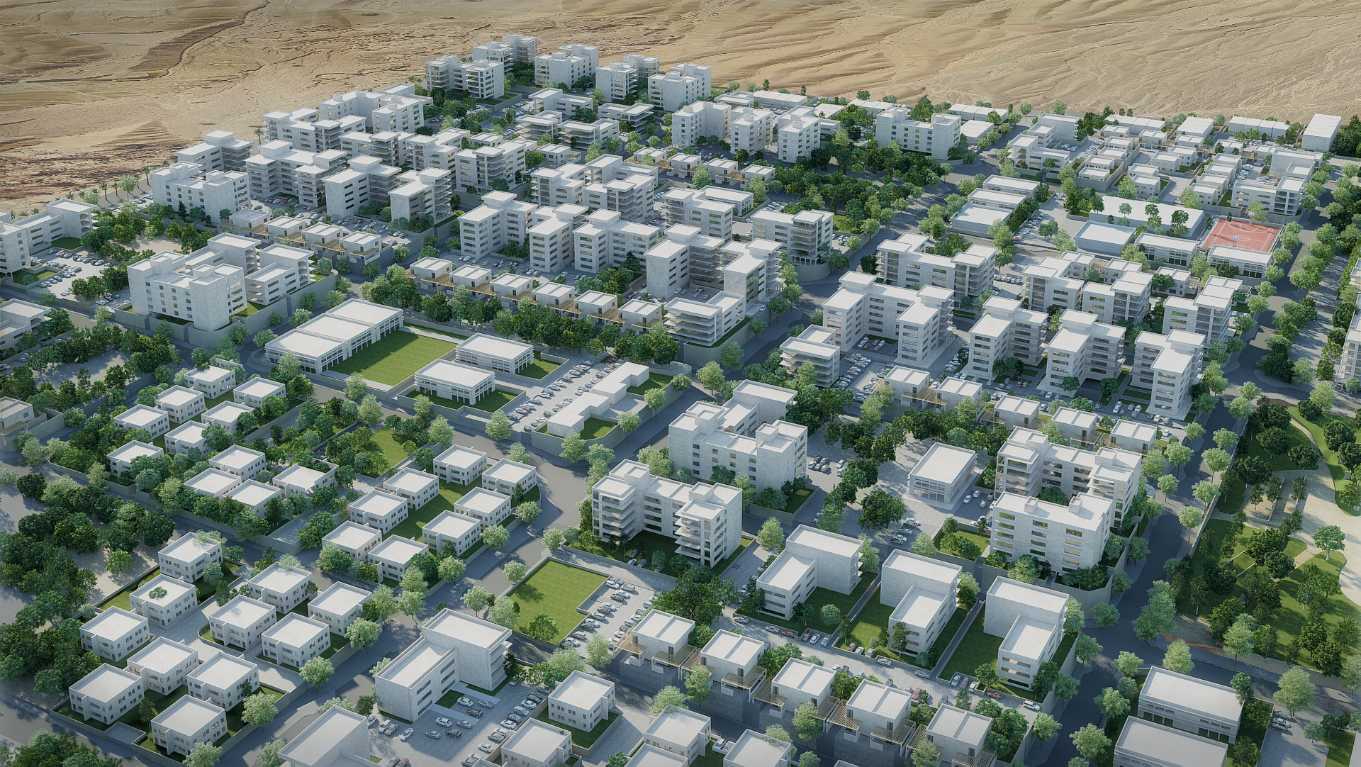
The Nahal Roded neighborhood is a new residential neighborhood in Eilat, on the northern side of the city near Kibbutz Eilot and upcoming city neighborhoods.
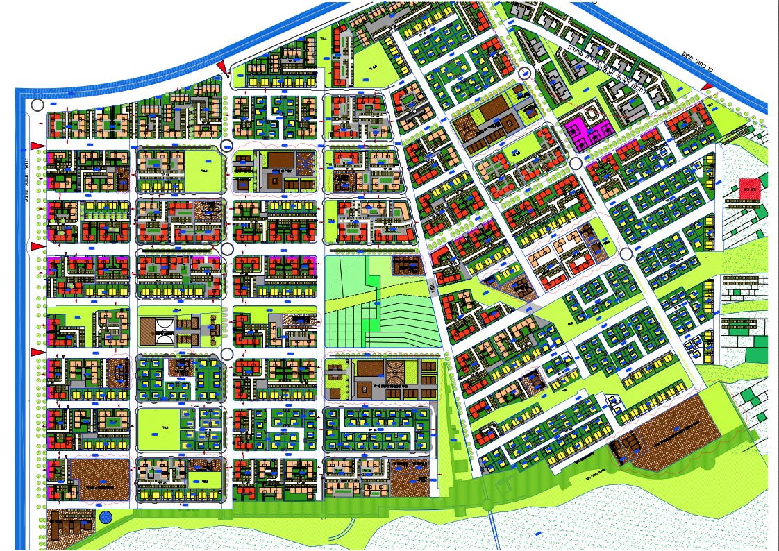
The neighborhood spans approximately 2,800 dunams, including a seismic zone and the Nahal Roded Nature Reserve, where construction and development are prohibited.
Soil uses include all uses that comprise a built-up urban area – different types of residences totaling 4,200 residential units, buildings designated for the public, education, employment, industry, sports, public open spaces, etc.
The city of Eilat wants to implement the philosophy of the green neighborhood as sustainable building that conserves resources, streamlines energy and water consumption, and reduces the emission of air pollutants and waste products, both at the construction stage and over the lifespan of the complex.
Dunams
Residential Units
Project details:
Head design company: Leitersdorf Ben-Dayan Architects
Design: Guggenheim Bloch Architects and Urbanists, Moshe Margalith Architects and Urban Planners
Landscape architecture: Miller-Blum
The challenge:
The planning of the neighborhood highlights the philosophy of sustainable city building, combining appropriate consideration of the harsh, unique environmental conditions with constructional, architectural solutions, to create an urban experience that is always desirable, especially in this area, to compensate for its distance from Israel’s center.
The sustainable design of the neighborhood addressed and assimilated elements from the measuring tools for sustainable neighborhood design – Neighborhood 360 – developed by the Israeli Green Building Council and the Ministry of Construction and Housing, and relevant, leading standards such as LEED ND, and by some of the world’s leading design philosophies in these aspects.
Key elements assimilated in the plan that contribute to developed, sustainable urbanism include: a dense urban network – small buildings, optimal connectivity for pedestrians, cyclists, and motor transportation both within the complex and in its surrounding construction, and the creation of a meaningful neighborhood center by concentrating most commercial and public activity in the neighborhood’s geographical center. This encourages people to walk and cycle to the center and to moderate conditions for the development of rich community activity in the public space, and more.
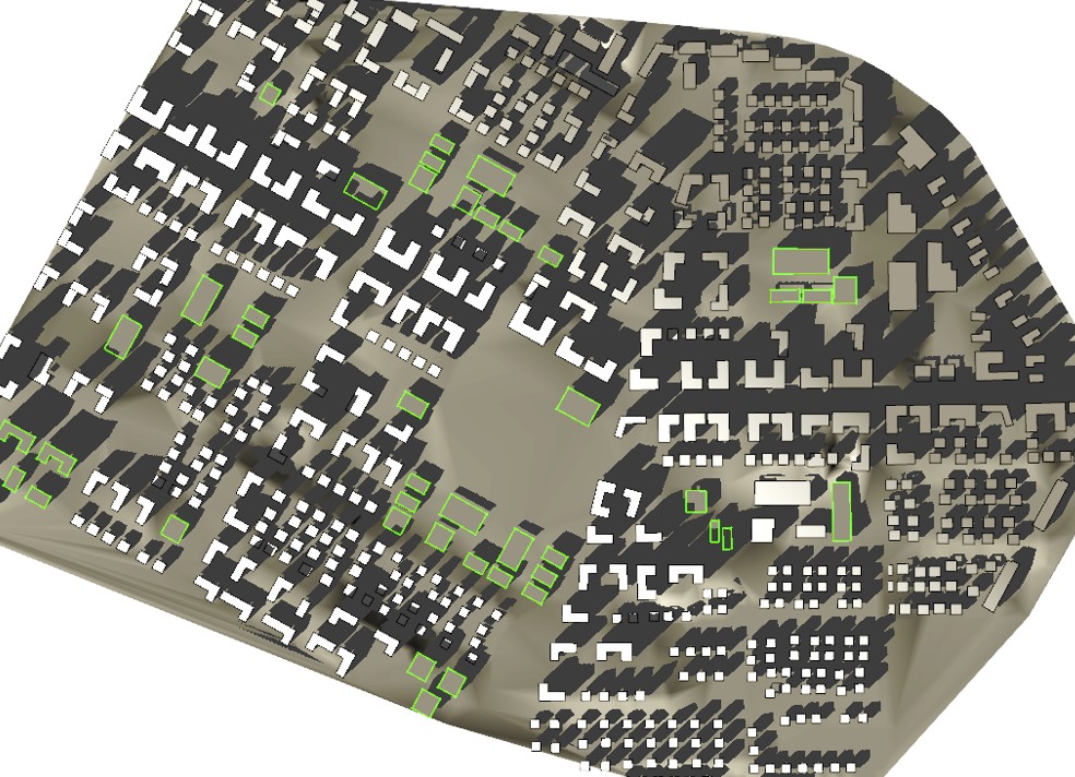
The neighborhood was designed in accordance with sustainable city construction principles. It addresses the unique physical and climatic attributes of the area and its inherent potential, considers the analysis of the area’s wind regime, and tests the impact of the reciprocal shading of the proposed construction. It ensures the preservation of the rights to light of occupants of the buildings, and that they receive sufficient exposure to the sun in the winter as well, enabling healthy, natural light in the buildings and the benefit of the sun in the open areas.
Climate:
Eilat’s location in the northern edges of the global desert strip and its distance from the Mediterranean Sea translate into a hot, arid climate marked by clear skies and minimal, irregular precipitation. The heat and aridity reach extreme levels in Eilat that are unlike other areas in the country. The proximity of the Gulf of Eilat does not translate into moderate climate conditions due to high prevailing northerly winds – from northeast to northwest – at all hours of the day and all seasons of the year.
The average temperature in the summer is roughly 33 degrees Celsius, frequently reaching 40 degrees, whereas the average temperature in the winter is about 16 degrees. In all seasons of the year, the temperature reaches its daily peak at about 3pm, and it starts to slowly cool down in the late afternoon and evening. At 8pm, the temperature is still 4-5 degrees higher than the temperature at 8am.
This daily progression is caused by the northerly winds blowing consistently throughout the Arava at most times of the day bringing in hot air, in contrast with the lesser southerly winds from the Gulf, which have a climatically moderating effect.
Climatic design
Bioclimatic design in open areas
The harsh, unique climatic conditions dictated the need to implement a range of passive solutions for city construction to address the challenging conditions and to improve the microclimate in the public sphere.
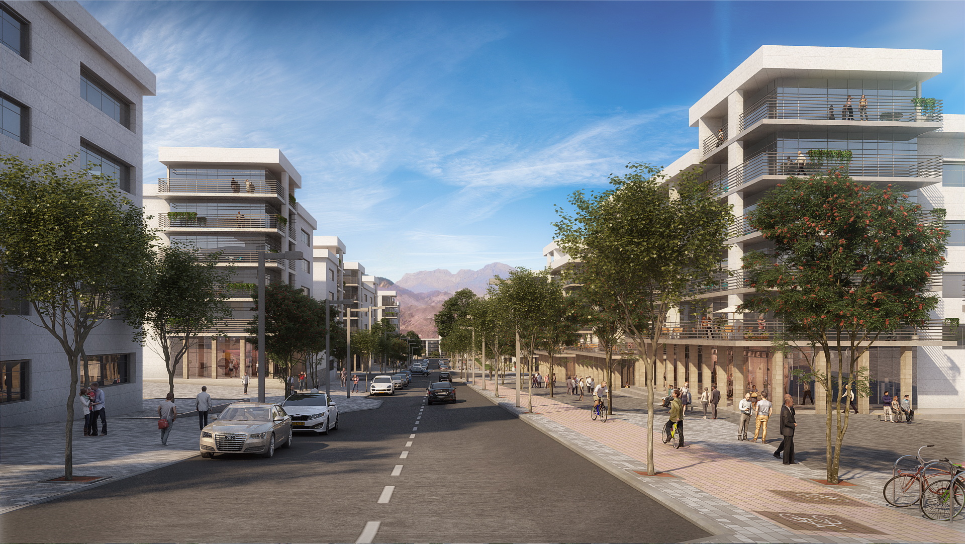
Solutions include redirecting the grid of the streets towards north-south to take in the northerly, albeit hot wind. This wind improves the comfort level due to its gusts, and the moderating southerly wind from the Gulf brings more comfortable temperatures.
Likewise, in the public open space, the urban squares, and the sidewalks, development elements that contribute to improving the microclimate, including ornamental pools, broad shady trees, vegetation covering and paving materials with low heat capacity, contribute to lower temperatures by cooling the air above them.
The aquatic gardens, a significant component in the development, are mostly situated in close proximity to ongoing activity – benches, a children’s play area, etc., reaping both climatic and visual benefits. The aquatic pools are partially covered with aquatic plants that reduce evaporation.
Grid directionality as a means to improve the microclimate
The grid of the neighborhood streets is designed to be directed towards the north in the direction of the cooler prevailing winds in the late afternoon and evening, in the summer and in transitional seasons. These streets also open towards significant areas in the public space, including the central public open space.
The northerly prevailing wind blows at hotter times of the day as well. While it is not a cooling wind, the breeze improves thermal comfort for people in the area.
Buffering undesirable winds
Directing the grid towards the prevailing wind also enables the penetration of undesirable wind in the winter that should be buffered, primarily in the areas of intensive outdoor activity in the public open space – commerce, public open space, and the outdoor areas of public buildings.
In order to achieve this goal, a significant number of mature trees will be planted – including a double boulevard on the main commercial street.
On the northern side of the central public open space, a public building is planned with intensive gardening in its center, including mature trees with a surrounding pergola – a collection of wind buffering elements.
Shading and rights to light
Shading is tested with the three following parameters:
- Shading of the planned buildings in the project on adjacent buildings.
- Shading of the adjacent constructed buildings (or prospective) on the planned buildings.
- Reciprocal shading between the planned buildings in the project (if there is more than one building).
Direct sunlight has many advantages:
- Heating of the building – primarily in the winter and during part of the transitional seasons, reducing the need for artificial heating that consumes energy and that entails high heating expenses, and improving thermal comfort conditions within the building.
- Natural light – reducing the need for energy consuming artificial light, thus cutting costs. Natural light also affects and improves peoples’ sense of wellbeing in the building and contributes to occupants’ health.
- It facilitates the generation of alternative energy, and as a result reduces electricity costs – by heating solar panels for heating water and photovoltaic (PV) panels for the generation of clean, renewable energy.
In certain conditions (humidity, air stillness, etc.), a permanent or semi-permanent situation with no direct sunlight can cause mold and fungus, and conditions inside the buildings have a negative impact on health and wellbeing.
Accordingly, we need to provide adequate direct sunlight both for the planned project and for the adjacent construction affected by it. The minimum amount of direct sunlight required in the winter is called rights to light.
The construction of the project was tested and designed with these aspects in mind, ensuring rights to light both at the façades of the buildings, on the roofs, and in public areas.
These aspects were taken into consideration when planning this neighborhood. They affected the distribution of the buildings, the space between them, and the height of the buildings in a manner that would provide all the required rights to light both on the roofs of the buildings for the generation of solar energy, on the southern façades for passive heating in the winter, and in parts of the development for exposure to the sun in the winter months.
Sustainable urbanism
Creating an improved microclimate in the public sphere that does not stand alone, but rather as an objective designed to serve the core value of sustainable urban construction: the experience of sustainable urbanism.
Bringing back the attributes of a vibrant, active city street that had diminished in the past few decades due to suburbanization, the malls, and land distribution by use, and due to the dominance of traffic engineering – roads and parking – to the entire planned space in a manner that ‘roads’ became ‘streets,’ and human activity in the public sphere became ‘traffic arteries.’
The project is designed in a way that encourages activity in the public sphere: encouraging pedestrian and bicycle traffic, socializing in the squares and in sitting areas on the sidewalks, sitting in cafés, playing with the sports facilities, wandering along the storefronts, etc.
This is all achieved by creating a public space that is conducive to traffic, diverse, attractive, and rich with opportunity, while maximizing soil use efficiency, conserving energy for building acclimatization, and more.
These are the key components assimilated in planning this project:
A dense street network
The plan is based on a street network with relatively small city blocks of 80/160 m, creating many intersections per unit of land. In this manner, traffic ways, both for motor vehicles and for pedestrians/cyclists, are varied and shorter.
Likewise, the large number of intersections enables different definitions of the public sphere through different intersection attributes, due to building rights and permitted designations. The detailed planning stage will enable the creation of visual diversity (different size and design for the buildings and the development in different intersections). It will also facilitate programmatic variety by granting rights for different activity – commercial, small public buildings, etc., reinforcing the unique identity and distinction of different areas in the neighborhood.
The resulting variety and design qualities of the public space bolster activity and the urban experience.
Inner paths were integrated in the city blocks that divide the private constructed sequence and add a range of paths that offer shorter distances to different destinations, thus encouraging people to walk and cycle.
Connectivity – Connecting to the constructed, existing, planned space
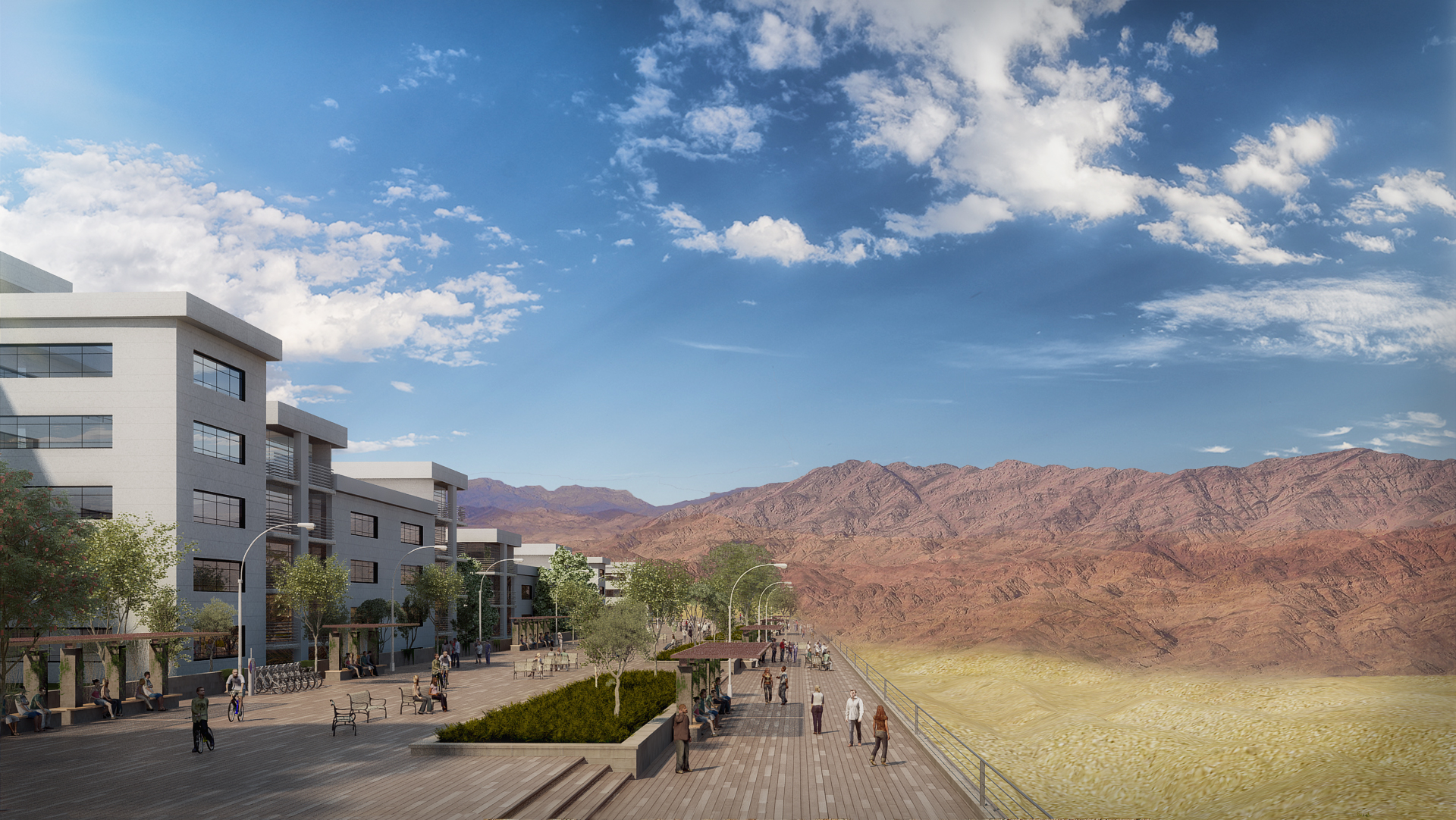
The plan creates optimal bi-directional connectivity between the planned neighborhood and its adjacent neighborhoods, designed to ensure accessibility between the residential buildings to the focal points of activity – education, commerce, public institutions, and a variety of services. Connecting the neighborhood to the existing, planned urban fabric adjacent to the neighborhood is achieved by maximizing the number of continuous roads, bicycle paths, and pedestrian paths, which intertwine and successfully continue the paths and bicycle paths in the adjacent neighborhoods, with emphasis placed on those that lead to public functions.
This plan takes natural limitations into account, primarily on motor vehicle roads: the Black Hills nature reserve to the north, and Nahal Roded to the south, the Birding Center to the southeast, and the seismic zone where construction is prohibited.
High connectivity improves the utilization of natural and public resources, improves occupants’ options for the efficient, convenient use of these resources, and improves the sense of urbanism.
Efficient use of public buildings
The physical plan – the location of the public buildings, distribution, public transportation, means for reducing traffic, connectivity to the bicycle network, well-lit parking for cars and bicycles, etc., and the zoning standard, are all designed to facilitate and encourage the community’s efficient use of the public buildings – schools’ sports fields and gyms, classrooms designated for after-school activities, courses, etc. – after operating hours.
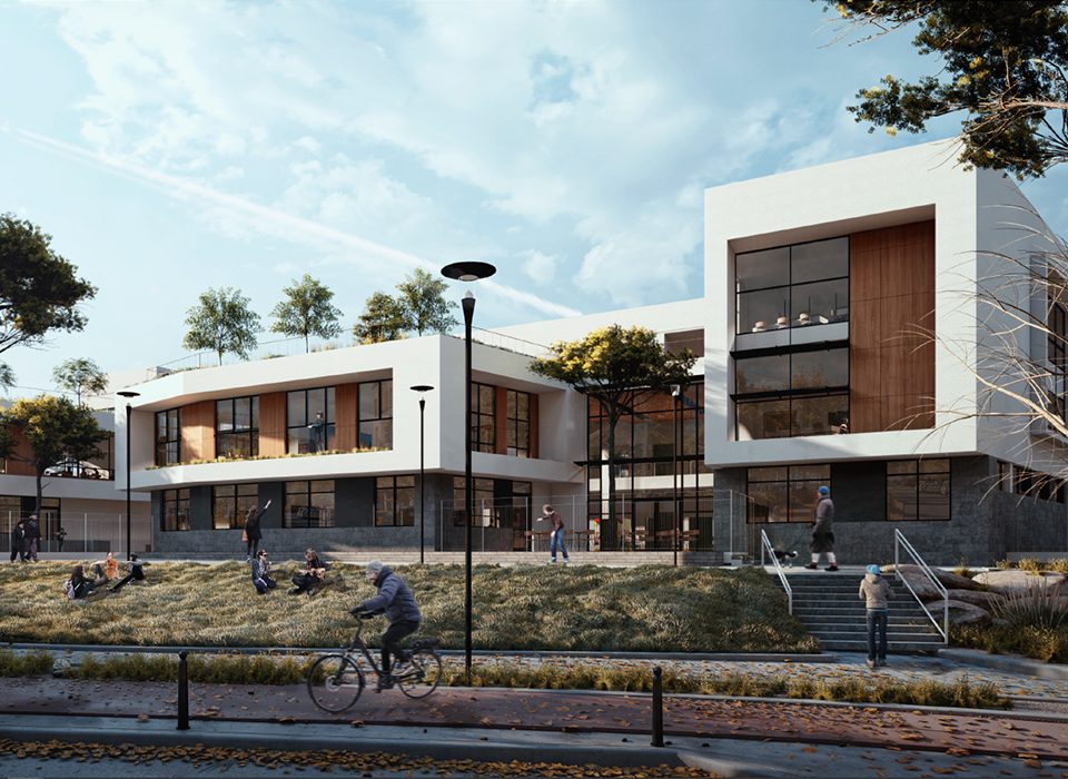
Moreover, the school buildings are designed to create a built-up façade that contributes to the urban vibe, with an entrance area and climatic solutions that include shading, vegetation, water, etc. This façade enables and invites residents’ activity in the complex.
Convenient walking distances to commerce, education, and leisure facilities
A key principle in sustainable urbanism was implemented in the design – the proximity of most of the residential units to most commercial and educational services, public buildings, etc., that eliminate the need to drive by facilitating pedestrian and bicycle access. The design objective was a proximity of a 300-350 m walk or a bicycle path up to 3 km long, distances that are considered convenient and inviting for walking or cycling.
Therefore, the plan concentrated most commerce and services possessing an active urban character (stores, the offices of professional service providers, and various other services), as well as the main public open space, in the geographical center of the neighborhood. Education and public buildings were placed on the second ring, homogenously distributed around the center, in locations that serve the population in this section of the neighborhood.
Open areas
These are a variety of planned situations for activity in the neighborhood’s public space:
In order to enrich the urban experience, which stands at the heart of sustainable urbanism, the plan combines and includes spaces that suit and enable intensive, varied outdoor activity – a play area and meeting point for children, seating areas for adult interaction, exhibitions, streets performances, etc. These spaces are primarily situated in areas of commerce and on main roads – the heart of the neighborhood’s urban activity.
The plan also integrates different size gardens in the built-up fabric – from a large 20 dunam public open space to square gardens, as well as small gardens designed and adapted to suit a variety of outdoor activities.
These spaces and gardens will also include a range of seating arrangements – from a singular bench to a cluster of benches to seat groups of people. These benches would encourage social interaction, and will be shaded by trees or pergolas covering a significant portion of the area, as well as open areas for a range of activities. A portion of these areas is designed without shading in order to allow exposure to the sun in the winter.
The spaces include landscaped areas, development that includes water elements, and low heat capacity, highly reflective paving materials to improve the microclimate and to create a visually inviting area.
The built-up fabric is mostly surrounded by expansive, unique natural areas that offer nearby, closely available leisure activity spots.
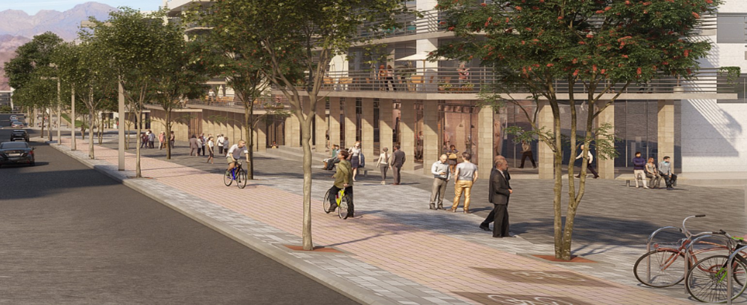
Livable streets
Intensive operation in the public space that characterizes vibrant urbanism is a primary objective in sustainable urban construction. A key component in achieving this objective is livable streets.
Central elements that meet the definition of streets that promote walking that were implemented in the design of the neighborhood in general and in the central commercial streets in particular:
- Continuous sidewalks with minimum interruptions like entrances to parking lots or to continuous commercial façades.
- Wide sidewalks with shaded sitting areas, vegetation, and high-quality, inviting street furniture.
- Gardening strips and bicycle paths that along with parallel parking, serve as a partition between the sidewalk and the street. This creates positive, safe conditions for walking and spending time in the sitting areas on the sidewalk.
- Shading the sidewalk using dense, mature trees that provide shade for the pedestrian network.
- Inviting, continuous commercial façades are designed for the commercial streets, usually with deep, tall arcades above the commercial façade.
- Parallel parking along the sidewalks of the commercial street, to enhance commercial activity in the area.
- The location of the main entrances to the buildings directs the pedestrian traffic network, with entrances to public buildings situated in wide spaces branching out from the traffic network.
We implemented all of these components throughout the entire neighborhood, with emphasis placed on the main, commercial streets.
Bicycle and pedestrian paths
An efficient, convenient, safe and continuous network of bicycle paths is planned for the neighborhood – both on the roads and on internal tracks, paths, and public open spaces. This network provides access between all the residential buildings and the public buildings, and to the intensive activity areas in the public space.
Throughout the entire length of the sidewalks, the bicycle paths are separated from pedestrians by a garden strip, and they are separated from motor traffic by a parking strip that is parallel to the sidewalk. This ensures the safety both of cyclists and of pedestrians.
On neighborhood streets where there is no bicycle path, traffic calming devices are implemented.
The sidewalks along the streets of the project are wide, continuous, and shaded by dense trees.
In public activity areas, including the commercial center and public and education buildings, an ample number of bicycle parking racks will be erected – with a bicycle stand for securely attaching bicycles placed in an open, well-lit area that is visible to pedestrians and visitors.
The dense grid with its many intersections and crosswalks creates high connectivity that is safe for pedestrians and cyclists.
Physical speed bumps will be placed opposite public and education institutions, connecting the two sides of the street with the sidewalks protruding in place of parallel parking.
Parking
Parking is planned to be parallel to the sidewalks on both sides of all the main roads, in order to bolster urban activity on these streets. In contrast, the plan does not include carparks, in order to avoid non-built-up spaces that interrupt the built-up continuum and the character of the street.
Parallel parking also contributes to pedestrian safety, as it serves as a partition between motor traffic and the sidewalk.
The wider parking lots – both the private lots that are situated in the heart of the residential buildings and the public lots situated near public institutions, public open spaces, etc. – are designed in clusters of up to 20 parking spots with a significant partition of landscaped land between them.
The parking spots are shaded by mature shade trees for every 4 spots, or by a pergola or built-up shading where the installation of a PV system is permitted.
Public transportation and traffic moderation
The neighborhood plan includes optimally distributed public transportation that provides residents with maximum convenience, thus encouraging its use. Public transportation routes cover all the main roads in the neighborhood as well as roads that outline the neighborhood.
The stations are positioned in a manner where a they are distanced at a radius of 250 m from the entire neighborhood.
The plan included the positioning of public transportation stations next to schools and the neighborhood’s main public institutions.
On side streets, where public transportation does not reach, a variety of methods were employed to moderate traffic, such as raised intersections, speed bumps at every 70 m, and more.
Sustainable development
Additional components of sustainable planning that address the various concerns in the development of the public space, which are implemented both in the plan and in zoning guidelines, include, among others:
- Local vegetation that does not need a lot of water and computerized irrigation for conserving freshwater and purified water.
- The use of low-maintenance, durable street furniture, paving materials and other materials.
- Moderation of the urban heat island effect – the temperature is higher in an urban area than it is in a non-built-up area – by using suitable paving and surfacing materials in the development, including light paving materials with low heat capacity that do not cause glare, vegetation covering as many areas as possible, and shaded areas.
- In order to prevent light pollution caused by light fittings in the public space – on the streets, in public open spaces and in the squares – the plan determines the use of cutoff light fittings that do not emit light towards the sky, to minimize light leakage from areas that need to be lit up.
Generation of renewable energy
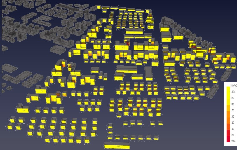
The analysis of the roofs’ exposure to direct sunlight indicates that all the roofs in the Nahal Roded neighborhood benefit from over six hours a day of exposure to direct sunlight, even in the winter months. This points to high potential for generating electricity from solar energy.
Zoning regulations recommend and approve the installation of PV panel systems on the roofs of public buildings and in the public space. These systems serve as a tool to conserve energy from perishable, polluting sources, to cut ongoing operations costs, and to demonstrate an educational, public value. These regulations would be subject to a test that indicates the level of sun exposure in order to determine financial feasibility.
Likewise, there is approval to install PV systems on the roofs of the private buildings and as roofing for privately owned stores in the lots, as subject to the examination of financial feasibility.
Pneumatic system for waste collection
The plan includes a pneumatic waste collection device comprised of a system of underground pipes with a 60 cm diameter connecting all the buildings (besides ground-bound buildings) to a main terminal equipped with garbage compactors. Garbage trucks arriving at the terminal building direct the garbage compactors to a site designated for waste treatment.
The terminal building is planned to be situated in the employment area at the edges of the neighborhood, adjacent to the exterior access road, in order to prevent the entry of trucks into the neighborhood, and to enable easy access for garbage collection trucks.
Smart city
The neighborhood was designed with a vision of a smart, resilient city as set in the zoning regulations in land allotment and in system design. The plan allocated a place for a control and monitoring system in a public building situated in the central public open space, which is located in the center of the neighborhood.
The control and monitoring room assembles information from all the monitored systems in the neighborhood complex: monitoring centers for energy consumption and local generation of renewable energy, monitoring street lighting, traffic lights, water leaks, the height of pipes, the pneumatic system, security cameras in the public space, and more.
The center is connected through a fiber-optic communication infrastructure, or piping for other communication cable infrastructures for transmitting information from different parts of the neighborhood to the monitoring room, and from there to all the controlled systems.
Beyond the operational issue, the center serves as a tool for sharing a wide range of topics with the community. This creates a tool for increasing environmental awareness, for enlisting the community to take steps towards environmental conservation and conservation of water, energy, and other resources, for sharing local entertainment, knowledge and culture, for creating a sense of community – mutual support, donations, shared events, and for sharing relevant information with residents on a multitude of topics.